Miranda Project

Nevada, USA | 5,360 Acres

Project Summary

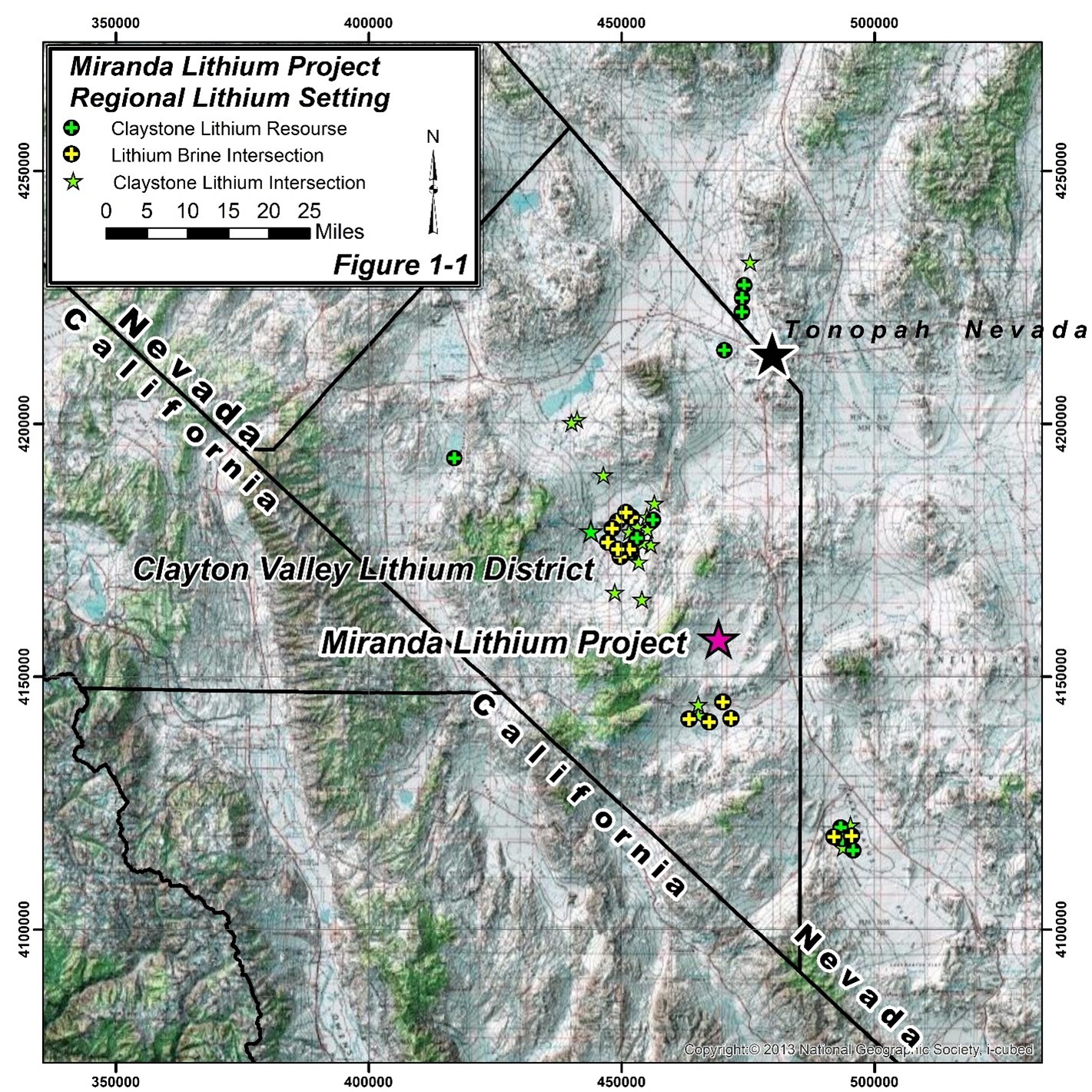
The Miranda project is a significant lithium exploration project encompassing 268 placer claims over a 5,360-acre expanse in Jackson Valley, Nevada. Jackson Valley falls between the Montezuma and Goldfield Ranges and is situated adjacently southeast of Clayton Valley; the host of the United States’ sole lithium production facility. The similar geology between Jackson and Clayton valley places the Miranda project in an area of significant lithium exploration potential.

This potential has been significantly upgraded by the very recent discovery of well lithium mineralized claystone by Nevada Sunrise (CVE: NVE) at their Gemini project located seven miles south of Miranda.

Project Highlights

5,360 Acres
100% Ownership
Significant Existing Infrastructure
6 hour drive to the Teslas Gigafactory
Located in Mining friendly Nevada, USA

The Miranda project is in close proximity to the heavily explored Goldfield Mineral District, 5 miles to the north. This locality has seen numerous prospects for gold, silver, copper, lead, and zinc placing the Miranda project in a region of significant economic geologic interest. The Miranda project claims are readily accessible via two county gravel roads and numerous two-track roads.

The Miranda Project expands westerly upon pre-existing lithium placer claimants held by Nevada Sunrise Gold Corp. Jackson Valley obsidian fragments, analyzed by Nevada Sunrise Corp returned significant assay values of 97-117 parts-per-million (ppm) of lithium. New placer claims capitalize on this and existing geophysical data, expanding into an area of potentially substantial lithium concentration.

Jackson Valley is a basin and range down-dropped graben. The valley is down-dropped via normal faulting. Geophysical testing revealed a significant gravitational low through the central belt of Jackson Valley. This testing indicated the valley is upwards of 800m deep and infilled with coarse alluvium, deposited over the last several million years. Results of geologic mapping indicate groundwater flow to the south, and west of Nevada Sunrise claims.

The Jackson Valley region bears lithium-rich geology. The southwest portion of the surrounding Montezuma range is composed of a thick sedimentary sequence intruded by numerous rhyolitic dykes, likely the source of tested, lithium-rich obsidian fragments. The northeast section of the range is similar; the sedimentary sequence is overlain by a thick mass of rhyolitic tuff. Erosion of surrounding mountain ranges likely formed the coarse alluvium and is understood to be a primary lithium source. Lithium is supplied to the basin through weathering of volcanic rocks and dissolution and transport of lithium by surface and groundwater.

Coarse alluvium permits the accumulation and storage of lithium-rich groundwater in abundant pore space. High rates of evaporation in the valley concentrate lithium which is highly soluble and does not readily form evaporite crystals. Thus, concentration is increased in unevaporated waters. Specifics of subsurface Jackson valley stratigraphy are unknown. In Clayton Valley, lithium brine aquifers are bound by low porosity claystone and mudstone beds, similar subsurface stratigraphy is expected in Jackson Valley given the concurrent development of both basins.

Jackson valley is a closed system, crucial for long-term lithium accumulation and attributed to the region’s arid climate. The nature of a closed system is one in which water entering the basin does not have a surface outflow. In the past this prevented paleo lakes of Jackson Valley overflowing which would drain lakes, carrying away dissolved lithium. In the modern, the closed system of Jackson valley refers to the lack of drainage routes available for water entering the basin via precipitation. As water is unable to drain the valley it becomes stored in aquifers within the coarse alluvium as lithium-rich brines.

Jackson Valley is an ideal geologic setting for the accumulation of lithium brines through the entrapment of surface and groundwater within the basin. The local geology offers an abundant lithium source with the arid, closed environment enhancing concentrations. In north-eastern Jackson valley, steep normal faulting has created subsidiary basins at which lithium-rich brines may pool, similar geologic conditions may present themselves within the Miranda project claims.

Miranda Project placer claims lie in central Jackson valley, between the Montezuma Range to the west and north and the Goldfield range to the east. The placer claims encompass both the gravitational low and groundwater flow direction with subsurface geology consisting of coarse alluvium. It is interpreted that aquifers exist in the valley fill, similar to those in Clayton Valley. Outcrops of alluvium are present in northern placer claims. Lithium source rocks outcrop in the Montezuma Range to the east, erosion of these rocks resulted in lithium-bearing valley fill and surface and groundwater.

Lithium may also be present within basin fill claystones, mudstones and ash stones.  While the Miranda project is primarily a lithium brine exploration project, the potential for subsurface, lithium rich stratigraphy is likely given the geology of the basin and the existence of significant claystone lithium resources and recent discoveries in the adjacent Clayton Valley and Lida Wash areas.

Geophysical program commenced in June 2022, consisted of a detailed Hybrid-Source Audio-Magnetotellurics (“HSAMT”) and high-quality seismic reflection surveys carried out by Hasbrouck Geophysics Inc. The Scotch Creek team completed a soil sampling program in late 2023, confirming the presence of lithium on the Miranda property.

Photo Gallery